


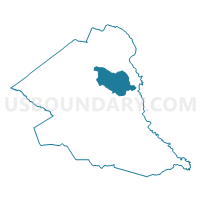
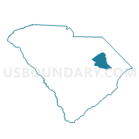
Claussen Voting District, Florence County, South Carolina
About
Outline

Summary
| Unique Area Identifier | 665729 |
| Name | Claussen Voting District |
| County | Florence County |
| State | South Carolina |
| Area (square miles) | 36.17 |
| Land Area (square miles) | 36.13 |
| Water Area (square miles) | 0.03 |
| % of Land Area | 99.91 |
| % of Water Area | 0.09 |
| Latitude of the Internal Point | 34.12178300 |
| Longtitude of the Internal Point | -79.64563090 |
Maps

Graphs
Select a template below for downloading or customizing gragh for Claussen Voting District, Florence County, South Carolina


Neighbors
Neighoring Voting District (by Name) Neighboring Voting District on the Map
- Effingham Voting District, Florence County, SC
- Evergreen Voting District, Florence County, SC
- Gilbert Voting District, Florence County, SC
- Greenwood Voting District, Florence County, SC
- Mars Bluff No. 1 Voting District, Florence County, SC
- Mill Branch Voting District, Florence County, SC
- Pamplico No. 1 Voting District, Florence County, SC
Top 10 Neighboring County Subdivision (by Population) Neighboring County Subdivision on the Map
Top 10 Neighboring Place (by Population) Neighboring Place on the Map
Top 10 Neighboring Unified School District (by Population) Neighboring Unified School District on the Map
Top 10 Neighboring State Legislative District Lower Chamber (by Population) Neighboring State Legislative District Lower Chamber on the Map
Top 10 Neighboring State Legislative District Upper Chamber (by Population) Neighboring State Legislative District Upper Chamber on the Map
Top 10 Neighboring 111th Congressional District (by Population) Neighboring 111th Congressional District on the Map
Top 10 Neighboring Census Tract (by Population) Neighboring Census Tract on the Map
- Census Tract 16.01, Florence County, SC (6,084)
- Census Tract 5, Florence County, SC (6,018)
- Census Tract 16.02, Florence County, SC (5,221)
- Census Tract 17, Florence County, SC (2,488)